| at: |
Brawley Mountain Trans North Georgia |
Data from David Muse
 show on map
 animate
Trail users:


Elevation Profile
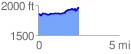
 2.505529 mi
 238.74 ft
 136.21 ft
 102.52 ft
 1.80 %
GPX Downloads: Track Route
![]()
| at: |
Brawley Mountain Trans North Georgia |
show on map
animate
2.505529 mi
238.74 ft
136.21 ft
102.52 ft
1.80 %