| at: |
Tsali Recreation Area |
Data from David Muse
 show on map
 animate
Trail users:


Elevation Profile
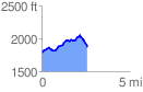
 2.600403 mi
 440.10 ft
 375.71 ft
 64.39 ft
 3.21 %
GPX Downloads: Track Route
![]()
| at: |
Tsali Recreation Area |
show on map
animate
2.600403 mi
440.10 ft
375.71 ft
64.39 ft
3.21 %