| at: |
Tsali Recreation Area |
Data from Positive Flow
 show on map
 animate
Trail users:


Elevation Profile
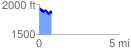
 0.780873 mi
 175.02 ft
 231.25 ft
 -56.23 ft
 5.61 %
GPX Downloads: Track Route
![]()
| at: |
Tsali Recreation Area |
show on map
animate
0.780873 mi
175.02 ft
231.25 ft
-56.23 ft
5.61 %