| at: |
Fort Ord Public Lands |
Data from David Muse
 show on map
 animate
Trail users:


Elevation Profile
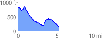
 5.332176 mi
 469.93 ft
 1111.14 ft
 -641.21 ft
 3.95 %
GPX Downloads: Track Route
![]()
| at: |
Fort Ord Public Lands |
show on map
animate
5.332176 mi
469.93 ft
1111.14 ft
-641.21 ft
3.95 %