| at: |
Fort Ord Public Lands |
Data from Jason Sager
 show on map
 animate
Trail users:


Elevation Profile
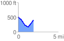
 1.982405 mi
 340.59 ft
 451.74 ft
 -111.15 ft
 4.32 %
GPX Downloads: Track Route
![]()
| at: |
Fort Ord Public Lands |
show on map
animate
1.982405 mi
340.59 ft
451.74 ft
-111.15 ft
4.32 %