| at: |
Fort Ord Public Lands |
Data from David Muse
 show on map
 animate
Trail users:


Elevation Profile
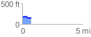
 0.730069 mi
 23.89 ft
 59.00 ft
 -35.11 ft
 1.53 %
GPX Downloads: Track Route
![]()
| at: |
Fort Ord Public Lands |
show on map
animate
0.730069 mi
23.89 ft
59.00 ft
-35.11 ft
1.53 %