| at: |
Fort Ord Public Lands |
Data from David Muse
 show on map
 animate
Trail users:


Elevation Profile
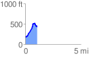
 1.066979 mi
 361.49 ft
 128.05 ft
 233.44 ft
 6.42 %
GPX Downloads: Track Route
![]()
| at: |
Fort Ord Public Lands |
show on map
animate
1.066979 mi
361.49 ft
128.05 ft
233.44 ft
6.42 %