| at: |
Fort Ord Public Lands |
Data from Jason Sager
 show on map
 animate
Trail users:


Elevation Profile
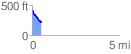
 0.548231 mi
 1.89 ft
 222.80 ft
 -220.91 ft
 7.70 %
GPX Downloads: Track Route
![]()
| at: |
Fort Ord Public Lands |
show on map
animate
0.548231 mi
1.89 ft
222.80 ft
-220.91 ft
7.70 %