| at: |
Fort Ord Public Lands |
Data from Jason Sager
 show on map
 animate
Trail users:


Elevation Profile
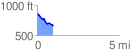
 0.988387 mi
 37.66 ft
 217.65 ft
 -179.99 ft
 4.17 %
GPX Downloads: Track Route
![]()
| at: |
Fort Ord Public Lands |
show on map
animate
0.988387 mi
37.66 ft
217.65 ft
-179.99 ft
4.17 %