|
| at: |
Fort Ord Public Lands |
Data from Jason Sager
 show on map
 animate
Trail users:


Elevation Profile
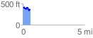
 0.605035 mi
 92.11 ft
 133.59 ft
 -41.48 ft
 4.18 %
GPX Downloads: Track Route
![]()
|
| at: |
Fort Ord Public Lands |
show on map
animate
0.605035 mi
92.11 ft
133.59 ft
-41.48 ft
4.18 %