|
| at: |
Fort Ord Public Lands |
Data from Jason Sager
 show on map
 animate
Trail users:


Elevation Profile
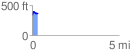
 0.337429 mi
 68.66 ft
 29.97 ft
 38.70 ft
 3.85 %
GPX Downloads: Track Route
![]()
|
| at: |
Fort Ord Public Lands |
show on map
animate
0.337429 mi
68.66 ft
29.97 ft
38.70 ft
3.85 %