| at: |
Fort Ord Public Lands |
Data from Jason Sager
 show on map
 animate
Trail users:


Elevation Profile
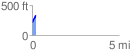
 0.206661 mi
 126.61 ft
 0.00 ft
 126.61 ft
 11.60 %
GPX Downloads: Track Route
![]()
| at: |
Fort Ord Public Lands |
show on map
animate
0.206661 mi
126.61 ft
0.00 ft
126.61 ft
11.60 %