|
| at: |
Fort Ord Public Lands |
Data from Jason Sager
 show on map
 animate
Trail users:


Elevation Profile
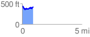
 0.943076 mi
 190.54 ft
 191.16 ft
 -0.62 ft
 3.84 %
GPX Downloads: Track Route
![]()
|
| at: |
Fort Ord Public Lands |
show on map
animate
0.943076 mi
190.54 ft
191.16 ft
-0.62 ft
3.84 %