| at: |
Fort Ord Public Lands |
Data from David Muse
 show on map
 animate
Trail users:


Elevation Profile
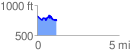
 1.179844 mi
 164.40 ft
 232.98 ft
 -68.57 ft
 3.74 %
GPX Downloads: Track Route
![]()
| at: |
Fort Ord Public Lands |
show on map
animate
1.179844 mi
164.40 ft
232.98 ft
-68.57 ft
3.74 %