| at: |
Fort Ord Public Lands |
Data from David Muse
 show on map
 animate
Trail users:


Elevation Profile
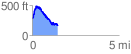
 1.488411 mi
 347.58 ft
 452.00 ft
 -104.42 ft
 5.75 %
GPX Downloads: Track Route
![]()
| at: |
Fort Ord Public Lands |
show on map
animate
1.488411 mi
347.58 ft
452.00 ft
-104.42 ft
5.75 %