| at: |
Fort Ord Public Lands |
Data from David Muse
 show on map
 animate
Trail users:


Elevation Profile
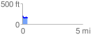
 0.430355 mi
 27.66 ft
 69.91 ft
 -42.25 ft
 3.08 %
GPX Downloads: Track Route
![]()
| at: |
Fort Ord Public Lands |
show on map
animate
0.430355 mi
27.66 ft
69.91 ft
-42.25 ft
3.08 %