| at: |
Fort Ord Public Lands |
Data from David Muse
 show on map
 animate
Trail users:


Elevation Profile
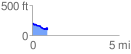
 0.896338 mi
 55.45 ft
 141.60 ft
 -86.15 ft
 2.99 %
GPX Downloads: Track Route
![]()
| at: |
Fort Ord Public Lands |
show on map
animate
0.896338 mi
55.45 ft
141.60 ft
-86.15 ft
2.99 %