| at: |
Fort Ord Public Lands |
Data from David Muse
 show on map
 animate
Trail users:


Elevation Profile
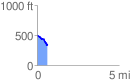
 0.665996 mi
 29.31 ft
 173.08 ft
 -143.77 ft
 4.92 %
GPX Downloads: Track Route
![]()
| at: |
Fort Ord Public Lands |
show on map
animate
0.665996 mi
29.31 ft
173.08 ft
-143.77 ft
4.92 %