| at: |
Fort Ord Public Lands |
Data from David Muse
 show on map
 animate
Trail users:


Elevation Profile
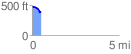
 0.511581 mi
 14.49 ft
 117.78 ft
 -103.29 ft
 4.36 %
GPX Downloads: Track Route
![]()
| at: |
Fort Ord Public Lands |
show on map
animate
0.511581 mi
14.49 ft
117.78 ft
-103.29 ft
4.36 %