| at: |
Fort Ord Public Lands |
Data from David Muse
 show on map
 animate
Trail users:


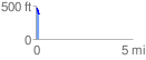
Elevation Profile
 0.187195 mi
 6.05 ft
 93.86 ft
 -87.81 ft
 9.50 %
GPX Downloads: Track Route
![]()
| at: |
Fort Ord Public Lands |
show on map
animate
0.187195 mi
6.05 ft
93.86 ft
-87.81 ft
9.50 %