| at: |
Fort Ord Public Lands |
Data from David Muse
 show on map
 animate
Trail users:


Elevation Profile
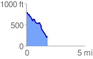
 1.825779 mi
 84.37 ft
 667.04 ft
 -582.68 ft
 6.92 %
GPX Downloads: Track Route
![]()
| at: |
Fort Ord Public Lands |
show on map
animate
1.825779 mi
84.37 ft
667.04 ft
-582.68 ft
6.92 %