| at: |
Fort Ord Public Lands |
Data from Jason Sager
 show on map
 animate
Trail users:


Elevation Profile
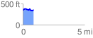
 0.875981 mi
 113.40 ft
 102.02 ft
 11.37 ft
 2.45 %
GPX Downloads: Track Route
![]()
| at: |
Fort Ord Public Lands |
show on map
animate
0.875981 mi
113.40 ft
102.02 ft
11.37 ft
2.45 %