| at: |
Northern Sierra Nevada - Downieville Area |
Data from Jason Sager
 show on map
 animate
Trail users:


Elevation Profile
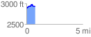
 0.755379 mi
 98.34 ft
 48.57 ft
 49.77 ft
 2.47 %
GPX Downloads: Track Route
![]()
| at: |
Northern Sierra Nevada - Downieville Area |
show on map
animate
0.755379 mi
98.34 ft
48.57 ft
49.77 ft
2.47 %