| at: |
Northern Sierra Nevada - Downieville Area |
Data from David Muse
 show on map
 animate
Trail users:


Elevation Profile
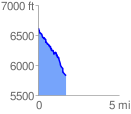
 1.756778 mi
 44.85 ft
 836.15 ft
 -791.30 ft
 9.01 %
GPX Downloads: Track Route
![]()
| at: |
Northern Sierra Nevada - Downieville Area |
show on map
animate
1.756778 mi
44.85 ft
836.15 ft
-791.30 ft
9.01 %