| at: |
Frank G. Bonelli Regional Park |
Data from Jason Sager
 show on map
 animate
Trail users:


Elevation Profile
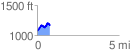
 0.790957 mi
 181.61 ft
 109.43 ft
 72.18 ft
 4.35 %
GPX Downloads: Track Route
![]()
| at: |
Frank G. Bonelli Regional Park |
show on map
animate
0.790957 mi
181.61 ft
109.43 ft
72.18 ft
4.35 %