| at: |
Frank G. Bonelli Regional Park |
Data from Jason Sager
 show on map
 animate
Trail users:


Elevation Profile
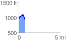
 0.751806 mi
 183.29 ft
 219.85 ft
 -36.56 ft
 5.54 %
GPX Downloads: Track Route
![]()
| at: |
Frank G. Bonelli Regional Park |
show on map
animate
0.751806 mi
183.29 ft
219.85 ft
-36.56 ft
5.54 %