| at: |
Frank G. Bonelli Regional Park |
Data from David Muse
 show on map
 animate
Trail users:


Elevation Profile
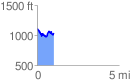
 1.037125 mi
 203.25 ft
 280.41 ft
 -77.15 ft
 5.12 %
GPX Downloads: Track Route
![]()
| at: |
Frank G. Bonelli Regional Park |
show on map
animate
1.037125 mi
203.25 ft
280.41 ft
-77.15 ft
5.12 %