| at: |
Frank G. Bonelli Regional Park |
Data from David Muse
 show on map
 animate
Trail users:


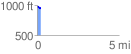
Elevation Profile
 0.244870 mi
 5.06 ft
 45.66 ft
 -40.60 ft
 3.53 %
GPX Downloads: Track Route
![]()
| at: |
Frank G. Bonelli Regional Park |
show on map
animate
0.244870 mi
5.06 ft
45.66 ft
-40.60 ft
3.53 %