| at: |
Frank G. Bonelli Regional Park |
Data from David Muse
 show on map
 animate
Trail users:


Elevation Profile
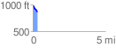
 0.305712 mi
 0.39 ft
 115.31 ft
 -114.92 ft
 7.14 %
GPX Downloads: Track Route
![]()
| at: |
Frank G. Bonelli Regional Park |
show on map
animate
0.305712 mi
0.39 ft
115.31 ft
-114.92 ft
7.14 %