| at: |
Coopers Creek WMA |
Data from David Muse
 show on map
 animate
Trail users:


Elevation Profile
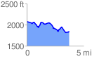
 3.736490 mi
 331.16 ft
 557.96 ft
 -226.80 ft
 2.83 %
GPX Downloads: Track Route
![]()
| at: |
Coopers Creek WMA |
show on map
animate
3.736490 mi
331.16 ft
557.96 ft
-226.80 ft
2.83 %