| at: |
Forest Park |
Data from Jason Sager
 show on map
 animate
Trail users:


Elevation Profile
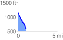
 1.013559 mi
 95.54 ft
 617.57 ft
 -522.03 ft
 11.54 %
GPX Downloads: Track Route
![]()
| at: |
Forest Park |
show on map
animate
1.013559 mi
95.54 ft
617.57 ft
-522.03 ft
11.54 %