| at: |
Forest Park |
Data from Jason Sager
 show on map
 animate
Trail users:


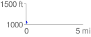
Elevation Profile
 0.105501 mi
 5.15 ft
 39.33 ft
 -34.19 ft
 7.06 %
GPX Downloads: Track Route
![]()
| at: |
Forest Park |
show on map
animate
0.105501 mi
5.15 ft
39.33 ft
-34.19 ft
7.06 %