|
| at: |
Ashland Watershed |
Data from Jason Sager
 show on map
 animate
Trail users:


Elevation Profile
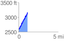
 1.129745 mi
 648.34 ft
 61.21 ft
 587.13 ft
 10.87 %
GPX Downloads: Track Route
![]()
|
| at: |
Ashland Watershed |
show on map
animate
1.129745 mi
648.34 ft
61.21 ft
587.13 ft
10.87 %