| at: |
Ashland Watershed |
Data from Jason Sager
 show on map
 animate
Trail users:


Elevation Profile
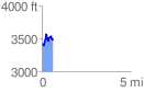
 0.621407 mi
 249.13 ft
 184.99 ft
 64.14 ft
 7.59 %
GPX Downloads: Track Route
![]()
| at: |
Ashland Watershed |
show on map
animate
0.621407 mi
249.13 ft
184.99 ft
64.14 ft
7.59 %