| at: |
Ashland Watershed |
Data from Jason Sager
 show on map
 animate
Trail users:


Elevation Profile
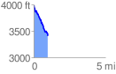
 0.989826 mi
 45.75 ft
 619.58 ft
 -573.83 ft
 11.86 %
GPX Downloads: Track Route
![]()
| at: |
Ashland Watershed |
show on map
animate
0.989826 mi
45.75 ft
619.58 ft
-573.83 ft
11.86 %