| at: |
Ashland Watershed |
Data from Jason Sager
 show on map
 animate
Trail users:


Elevation Profile
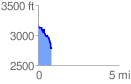
 0.849574 mi
 58.64 ft
 442.70 ft
 -384.06 ft
 9.87 %
GPX Downloads: Track Route
![]()
| at: |
Ashland Watershed |
show on map
animate
0.849574 mi
58.64 ft
442.70 ft
-384.06 ft
9.87 %