| at: |
Black Rock Mountain Bike Area |
Data from Jason Sager
 show on map
 animate
Trail users:


Elevation Profile
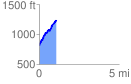
 1.071411 mi
 465.17 ft
 32.14 ft
 433.03 ft
 8.22 %
GPX Downloads: Track Route
![]()
| at: |
Black Rock Mountain Bike Area |
show on map
animate
1.071411 mi
465.17 ft
32.14 ft
433.03 ft
8.22 %