| at: |
Black Rock Mountain Bike Area |
Data from Jason Sager
 show on map
 animate
Trail users:


Elevation Profile
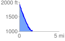
 1.682497 mi
 132.24 ft
 1061.40 ft
 -929.16 ft
 11.95 %
GPX Downloads: Track Route
![]()
| at: |
Black Rock Mountain Bike Area |
show on map
animate
1.682497 mi
132.24 ft
1061.40 ft
-929.16 ft
11.95 %