| at: |
18 Road |
Data from Positive Flow
 show on map
 animate
Trail users:


Elevation Profile
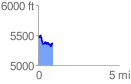
 0.943054 mi
 179.58 ft
 295.78 ft
 -116.20 ft
 5.94 %
GPX Downloads: Track Route
![]()
| at: |
18 Road |
show on map
animate
0.943054 mi
179.58 ft
295.78 ft
-116.20 ft
5.94 %