| at: |
18 Road |
Data from Positive Flow
 show on map
 animate
Trail users:


Elevation Profile
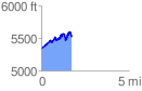
 1.780390 mi
 559.05 ft
 382.24 ft
 176.81 ft
 5.95 %
GPX Downloads: Track Route
![]()
| at: |
18 Road |
show on map
animate
1.780390 mi
559.05 ft
382.24 ft
176.81 ft
5.95 %