|
| at: |
Coopers Creek WMA |
Data from USFS GIS
 show on map
 animate
Trail users:


Elevation Profile
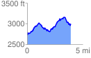
 3.929734 mi
 994.56 ft
 722.81 ft
 271.76 ft
 4.79 %
GPX Downloads: Track Route
![]()
|
| at: |
Coopers Creek WMA |
show on map
animate
3.929734 mi
994.56 ft
722.81 ft
271.76 ft
4.79 %