| at: |
Lajitas Trails |
Data from Jason Sager
 show on map
 animate
Trail users:


Elevation Profile
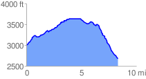
 8.449296 mi
 899.41 ft
 1233.15 ft
 -333.74 ft
 2.76 %
GPX Downloads: Track Route
![]()
| at: |
Lajitas Trails |
show on map
animate
8.449296 mi
899.41 ft
1233.15 ft
-333.74 ft
2.76 %