| at: |
Lajitas Trails |
Data from Jason Sager
 show on map
 animate
Trail users:


Elevation Profile
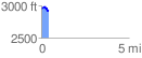
 0.441001 mi
 44.17 ft
 74.84 ft
 -30.67 ft
 3.21 %
GPX Downloads: Track Route
![]()
| at: |
Lajitas Trails |
show on map
animate
0.441001 mi
44.17 ft
74.84 ft
-30.67 ft
3.21 %