| at: |
Lajitas Trails |
Data from Jason Sager
 show on map
 animate
Trail users:


Elevation Profile
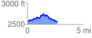
 2.679657 mi
 332.81 ft
 332.48 ft
 0.34 ft
 2.35 %
GPX Downloads: Track Route
![]()
| at: |
Lajitas Trails |
show on map
animate
2.679657 mi
332.81 ft
332.48 ft
0.34 ft
2.35 %