| at: |
Lajitas Trails |
Data from Jason Sager
 show on map
 animate
Trail users:


Elevation Profile
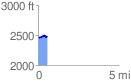
 0.551284 mi
 55.93 ft
 47.26 ft
 8.67 ft
 1.92 %
GPX Downloads: Track Route
![]()
| at: |
Lajitas Trails |
show on map
animate
0.551284 mi
55.93 ft
47.26 ft
8.67 ft
1.92 %