| at: |
Lajitas Trails |
Data from David Muse
 show on map
 animate
Trail users:


Elevation Profile
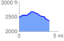
 3.927240 mi
 376.07 ft
 495.35 ft
 -119.27 ft
 2.39 %
GPX Downloads: Track Route
![]()
| at: |
Lajitas Trails |
show on map
animate
3.927240 mi
376.07 ft
495.35 ft
-119.27 ft
2.39 %