|
| at: |
Coopers Creek WMA |
Data from USFS GIS
 show on map
 animate
Trail users:


Elevation Profile
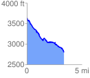
 3.408952 mi
 240.29 ft
 1074.33 ft
 -834.04 ft
 5.97 %
GPX Downloads: Track Route
![]()
|
| at: |
Coopers Creek WMA |
show on map
animate
3.408952 mi
240.29 ft
1074.33 ft
-834.04 ft
5.97 %