| at: |
Jackrabbit Trails |
Data from Positive Flow
 show on map
 animate
Trail users:


Elevation Profile
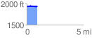
 0.911003 mi
 94.63 ft
 97.26 ft
 -2.63 ft
 2.02 %
GPX Downloads: Track Route
![]()
| at: |
Jackrabbit Trails |
show on map
animate
0.911003 mi
94.63 ft
97.26 ft
-2.63 ft
2.02 %