| at: |
Sherman Branch |
Data from Positive Flow
 show on map
 animate
Trail users:


Elevation Profile
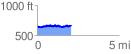
 2.092741 mi
 238.55 ft
 231.21 ft
 7.34 ft
 2.16 %
GPX Downloads: Track Route
![]()
| at: |
Sherman Branch |
show on map
animate
2.092741 mi
238.55 ft
231.21 ft
7.34 ft
2.16 %