| at: |
Lake Norman State Park |
Data from Positive Flow
 show on map
 animate
Trail users:


Elevation Profile
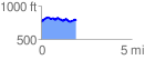
 1.942350 mi
 230.14 ft
 219.38 ft
 10.76 ft
 2.24 %
GPX Downloads: Track Route
![]()
| at: |
Lake Norman State Park |
show on map
animate
1.942350 mi
230.14 ft
219.38 ft
10.76 ft
2.24 %